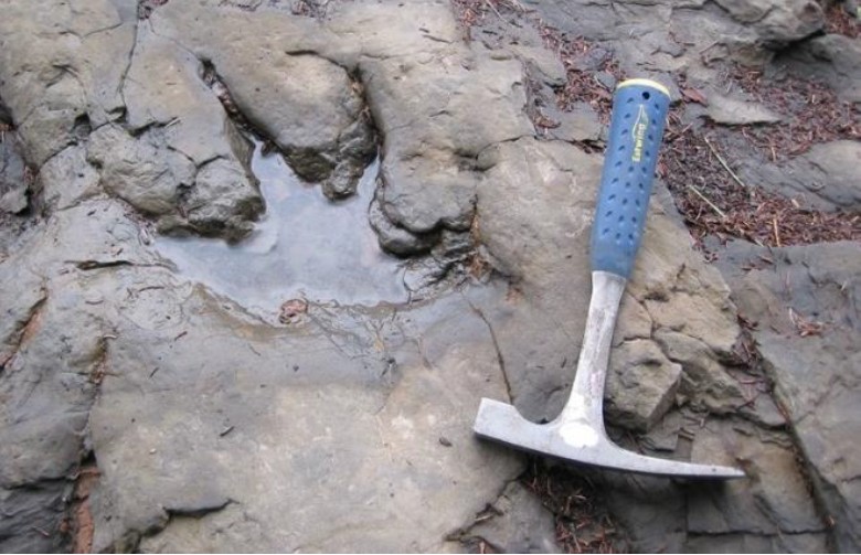
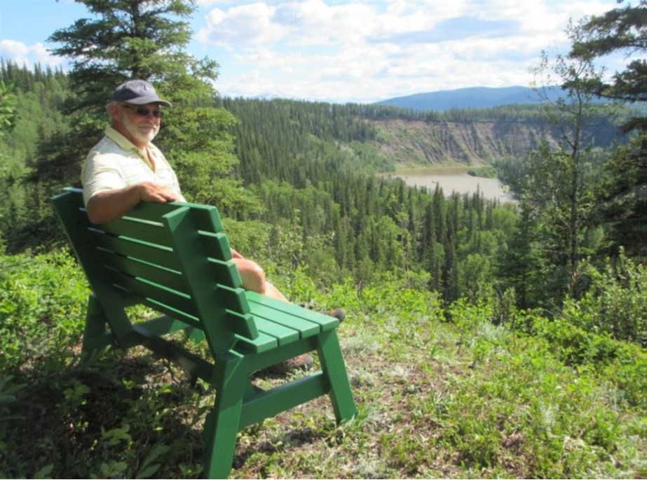
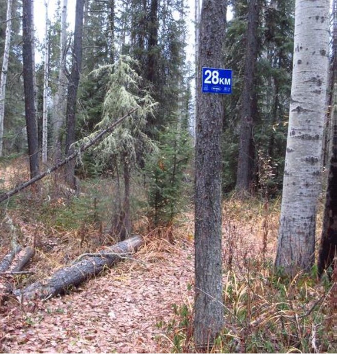
The 28 km TR Trail encircles three quarters of Tumbler Ridge without crossing a single paved road. Spur trails lead to waterfalls, rock formations, dinosaur tracks, picnic areas, river and creek-side portions, natural swimming pools, spectacular view-sites, and a backcountry cabin.
The TR Trail is a project of volunteers of the Wolverine Nordic and Mountain Society (WNMS) and the Tumbler Ridge UNESCO Global Geopark (TRUGG). It stitches together existing trails; some fall under WNMS, others under the District of Tumbler Ridge, others are user-maintained. Some are narrow improved game trails suitable for hiking and running, some are shared with ATVs and snowmobiles, and others with mountain bikers, cross country skiers and the Saddle Club.
Leg 1 - The first 3 km follow Kevin’s Trail. This probably follows an old pack trail noted on maps from the 1930s. Art Skinner was a legendary trapper in the region, and nearby are the remains of his 1930 cabin. The first viewpoint (km 0.9) is from the top of steep bluffs of unconsolidated Pleistocene (the time period characterized by repeated “Ice Ages”) glacial sediment. On the southern horizon are Mt. Babcock and Mt. Roman. The rocks that form these mountains are over 100 million years old, from the Early Cretaceous Period. Below runs Flatbed Creek, which has cut a wide channel through the sediment and the underlying bedrock.
Top Pool (km 3.6) is the first of many pools in Flatbed Creek along the TR Trail. It is formed by waters cascading over a ledge of resistant sandstone, forming a pool below that is suitable for swimming in summer. These rocks are from the Kaskapau Formation and are approximately 95 million years old, from the Cretaceous Era.
The “beach” at the Oysterbeds (km 3.8) is formed from the eroded, friable remains of marine rocks. Clams and other marine fossils may be found in such rocks nearby.
Overhanging Rock Pool (km 4) is one of the many attractive features along the trail. Here the fast-moving waters of Flatbed Creek slow down as they flow under horizontal rock layers. The main overhanging rock is formed from the same thick sandstone bed that crossed the creek at Top Pool.
At Cabin Pool (km 5.2) an exposed rock layer has dozens of dinosaur tracks, made by theropod, ankylosaur and ornithopod dinosaurs.
The ruined wooden structure at km 6 is Nominister Abbey. Visible in the valley below from the Razorback (km 6.3) and the Missing Link (km 6.5) are iron-rich spring-fed ponds, modified by beaver activity, and a home for waterfowl and other wildlife.
The same thick-bedded layer of erosion-resistant sandstone that forms the Overhanging Rock upstream is responsible for the formation of Flatbed Falls (km 7.4). The falls create a plunge pool that is suitable for jumping into after checking depth, but not for diving. Near the top of the Flatbed Falls spur trail there is a good view
into the valley of Flatbed Creek as it enters Flatbed Canyon (km 8.5 ).
Leg 2 - McManus bench (km 9.2) overlooks an attractive steep-sided section of Flatbed Canyon. Here the creek follows the centre of a gentle anticline (arch- shaped fold) along nearly horizontal layers of bedrock.
The Mini Falls (km 10.2) forms another cascade and deep pool suitable for swimming and jumping (check pool depth first) below gently dipping ledges. Many fossil burrows made by worm and shrimp are found in the rocks on the far side of the creek.
The steep south-facing slopes (km 11.3) below catch lots of sun and dry out quickly. Therefore they tend not to support trees, but instead are grass and brush covered, and are home to a different set of plants and flowers, birds and butterflies compared to what is found in the nearby forest.
Bridge Pool (km 12.1) is just upstream from the Hwy 29 bridge over Flatbed Creek. The cliffs on the far bank display an impressive section of rock strata.
Leg 3 - The trail climbs out of the flat area onto the level of Tumbler Ridge and proceeds along the Tumbler Point Trail toward Tumbler Point (km 14.9), with some fine views of the forest and Flatbed Creek below, above more open south facing slopes.
Bank Swallows nest in the bluffs below and can usually be seen flying around Tumbler Point in summer. The foothills in the distance to the south are (from left to right) Quintette Mountain, Roman Mountain, Mt Babcock and Mt Kostuik. They are all in older sedimentary rocks, over 100 million years old, and contain the extensive metallurgical coal deposits that are responsible for the existence of Tumbler Ridge.
The trail proceeds beyond Tumbler Point above the final reaches of Flatbed Creek as it enters the Murray River (km 15.1).
Where the trail reaches another bench (km 15.6) there is a view to the western horizon of the flat-topped bulk of Mt Spieker, another coal bearing mountain. Below you the Murray River Valley is joined by the Wolverine River Valley.
North-facing slopes are usually moist and thickly vegetated, but this is not the case at the Murray River viewpoint (km 15.9). The Murray River is actively washing away at the thick sands and gravels that form the river bank, and slides and small rockfalls are common.
Before reaching the golf course parking lot, the trail leads along the edge of a terrace, with outstanding views of the Murray River below and the foothills in the distance. There is a bench from which to enjoy the view. This section of the TR Trail is known as Nathan's Trail.
The Tumbler Ridge Golf Course (km 18.1) was developed in the early 1980s with the work of volunteers and contributions of personnel and equipment from one of the mines. The scenic nine hole course is on a series of terraces.
Leg 4 - The Wolverine Trails follow a series of north-south trending terraces perched above the river valley. On Larry’s Trail (km 20.9), valley-bottom vegetation is dominated by huge Cottonwoods.
On the slopes of Mt. Bergeron to the north is the spectacular line of the 95 million-year-old Bergeron Cliffs, a thick layer of non-marine sandstone deposits formed from ancient river channels which have cut into finer grained sandstone that geologists interpret as a beach deposit.
At the first short spur trail to the Murray River (km 21.3) a large slide can be seen upstream. Closer by is a wetland which is flooded in spring and after heavy rains, but usually dries up by the end of summer. This is a good place to look for wildlife. For the next few hundred metres (km 21.5) the river bank is being actively eroded by the fast- flowing river. The trail is relocated further inland every few years. It then passes over flood channels, where flagging tape indicates the way ahead.
The second spur trail leads left to the Murray River (km 22.3). Here, as the river curves left, it encounters a transition from the soft sediments of the Pleistocene deposits from the last Ice Age, to bedrock of the Late Cretaceous Kaskapau Formation, 95 million years old.
The ascent up Linda’s Trail (km 22.7) is the longest and roughest of the whole TR Trail, but provides interesting and different terrain. Here the land is hummocky, bumpy, and the trees are smaller. This is an old slope failure, now colonized by vegetation and stable enough to support trees. At one point the trail crosses a mildly active slide (km 23.1) where the trail has to be re- created each spring. Still higher up there is a sand dune (km 23.2), another legacy of the Pleistocene Glacial Lake Peace. Then the trail veers right and follows an established game trail to climb up to more level ground.
Lost Haven Cabin (km 23.3) is an excellent cross country ski destination in winter, and is a hub for hikers, mountain bikers and horseback riders in summer. It has a woodshed, indoor stove and outdoor barbeque area. Water is collected from rainfall only, so please be extremely careful with fires. Escher’s Loop provides further views (km 23.5) of the Murray Valley and Mt. Bergeron, as it traverses more benches.
The final viewpoint (km 24.6) at the end of a spur off Escher’s Loop offers a bench that overlooks the valley as the Murray River courses northwards.
A short series of boardwalks leads across a wet spot and tiny creek (km 25.6), which disappears into the ground nearby. It emerges as a spring some distance below, at the bottom of the sand level near the Lost Haven Cabin.
The TR Trail continues to follow the ski trails. At km 26.4 there is a side trail uphill to the left which leads to the TR Saddle Club. Continue gently downhill on the main trail, where the soil is sandy. The trail veers to the left off the ski trails at km 27.0. Shortly after this, the trail passes through a shallow valley with poorly drained soil, where a black spruce bog flourishes (km 27.2).
The trail skirts around an area logged by the Tumbler Ridge Community Forest in 2016 (km 27.5).
Finally, the last kilometre marker is seen (km 28.0), and the end of the trail is reached behind the ball diamonds.
Please download or take a brochure with you for more details regarding the geological, palaeontological, flora, and First Nations discoveries and importance of sites along the TR Trail.
The trail is signed in a clockwise direction. All signs are white-on-blue. Distance markers from 0 to 28 are placed every half kilometre, and directional arrows are placed at all junctions and significant corners. There are small blue diamonds or flagging tape every hundred metres.
A few parts of the TR Trail are steep, and work is ongoing to improve these through steps and hand-lines. In a few places it passes above steep dropoffs– caution signs warn trail users of these hazards. Pine-beetle infestation has led to many dead pine trees, so avoid hiking in very windy conditions as the risk of falling trees is greatest at these times. In the longer term, it is planned to extend the trail to form a complete circuit around Tumbler Ridge, which will include the spur trail up to the Bald Spot.
Leg 1 - Start to Flatbed Falls parking lot (7km)
To reach the beginning of the trail from the sign and parking area near the Gun Club, proceed along the ATV trail north beside Hwy 52 E for about 500 m, then cross the highway with caution to the sign marked “Kevin’s Trail” and the 0 km marker. The TR Trail initially follows Kevin’s Trail, then descends to the three Flatbed Pools. Top Pool and Overhanging Rock Pool which are good for swimming and have attractive rock formations, and Cabin Pool with its dinosaur tracks. It follows the Razorback onto the “Missing Link” before diverting to the Flatbed Falls parking lot.
Leg 2 - Flatbed Falls parking lot to Lions Campground parking lot (5km)
The trail heads down to Flatbed Falls, then back up to follow the Linking Trail, with an enjoyable spur down to the Mini Falls on Flatbed Creek. There are good views of Flatbed Canyon, and eventually the trail descends down to creek level, and crosses below the Hwy 29 bridge just after passing the Bridge Pool (also good for swimming).
Leg 3 - Lions Campground parking lot to Golf Course parking lot (5.5 km)
The TR Trail passes through deciduous forest, then climbs up to town level and follows the edge of the escarpment past Tumbler Point, with many good views of the valleys of the Murray and Wolverine rivers and the foothills. A sign near the campground commemorates the 2017 discovery of BC’s first dinosaur skull material and a nearby tyrannosaurid track.
Leg 4 - Golf Course parking lot to Ball Diamonds (10 km)
The TR Trail follows some of the Wolverine Trail, built as cross country ski trails, before descending to the Murray River via Larry’s Trail. There are spurs to two riverside sites with views of the Bergeron Cliffs, then it climbs up to the WNMS Lost Haven Cabin up Linda’s Trail (the roughest and most challenging section of the TR Trail). After following Escher’s Loop to a final viewpoint the trail leaves the ski trails and ends behind the ball diamonds
There are five signposted access points to the TR Trail: at the start beside Hwy 52 E near the Gun Club, the Flatbed Falls parking lot, Lions Campground parking lot, Golf Course parking lot, and at the back of the ball diamonds behind backstop #3. These conveniently break the total distance into four legs.
Please pack your garbage out.
Travel in groups and carry bear spray.
The TR Trail is up to 28km and is broken into four legs as described above. The trail is rated moderate to challenging with some steep sections. It may take up to 7 hours to complete the full route.
For more information, please contact the Tumbler Ridge Visitor Information Centre at 250-242-3123