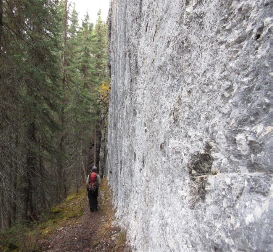
The Stone Corral hike will take you through an area with small caves and other limestone formations, ponds and many kinds of moving water, interesting and poisonous plants, fossils and magnificent viewpoints. Allow at least two hours for the hike and bring a flashlight for the caves.
The trail is rated moderate with some steep sections and considerable elevation change. There are a number of high vertical cliffs. The trail passes close to cliff edges, and children should be closely supervised. Make lots of noise on the trail, since black and grizzly bears are common in the area.
Geological Summary
Bedrock near the trailhead is made up of siltstone of early Triassic age (about 250 million years old) from the Sulphur Mountain Formation. Along the trail there is a transition to rocks of Mississippian age (340 million years old) from the Rundle Group. Elsewhere in the world, rocks of this time period contain the remains of great forests and produce large supplies of coal. Here, however, they were formed in warm shallow seas, much like the modern day Caribbean. These deposits became limestone, which was then dissolved by slightly acidic groundwater, creating what is known as a karst landscape of caves and sinkholes.
Remember to take or download the brochure for easy access. The "STOPS" in the brochure correspond to trail markers and points of interest along the trail.
Beaver Dams - A short side-trail leads down to a series of beaver dams which have formed the lake that fills the Green Bowl upstream.
Berries - You can find a remarkable variety of berries here in late summer and fall, including Black Huckleberry, Northern Gooseberry, Saskatoon, Wild Strawberry, Bunchberry and Soopallalie. Before tasting berries, it is important to be familiar with the toxic species first: don’t eat what you don’t know!
The Green Bowl - This is historic ground. In the entire history of northern B.C. and Alberta it is hard to find a tale of cooperative bravado and dedication that matches the building of the Monkman Pass Highway in the late 1930s.
Monkeyflower Creek - This creek flows all year, although it has a very small surface catchment area. Its temperature is a relatively constant 8 degrees Celsius.
Gentle Spring - The creek ends at another set of beaver dams holding back crystal clear water. The trail passes by a sizable spring, which is the source of the creek.
Surface Limestone Features - As you climb the stairs of this steep hill to reach a notch in Chambers Ridge, pause to examine the underside of this large overhanging limestone rock.
First Pond - The trail has passed through a notch and winds around the western shore of a pond. The far side at the foot of the cliffs is deeper and is the site of another
spring.
Devil's Club - The trail climbs up the moist valley between the first and second ponds. The shrub with the large maple-like leaves is Devil’s Club, a name that strikes terror into the heart of the bushwhacking hiker. Both the undersides of the leaves and the thick stems are filled with spines that easily penetrate the skin and tend to fester if not removed early.
Second Pond - The second pond is equally beautiful. It is lined by cliffs and also has underground drainage. The meadows lining this pond are home to the bluish-purple flowers of Mountain Monkshood.
The Stone Corral - A dark pond is circled on three sides by impressive vertical cliffs. The water looks deep, but scuba diving has shown that it is only 8 metres deep at most.
Fossils - Approximately 350 million years ago lime particles, corals and tiny shell fragments were deposited in a shallow warm sea. Fossil sites are easily damaged. Removing fossils from a provincial park is against the law.
Corral Cave - At the far end of the Stone Corral lies the large entrance to Corral Cave. Caves are fragile environments that need to be treated with the greatest respect. Do not touch the walls, take anything from the cave, or leave anything inside.
Chambers Ridge - The trail leaves the Stone Corral by a staircase through a weakness in the cliffs where forest and moss have taken hold, emerging onto Chambers Ridge at the top of the cliffs surrounding the Stone Corral.
Rock Folding - The slope you have climbed is very different from the lush valley floor. It is south facing and drier, with lots of Lodgepole Pine and Kinnikinnick (Bearberry). Look at the vertical rock strata contorted into wavy folds.
Mountain Death Camas - Look for the long grass-like leaves of Death Camas, a highly toxic plant and one of the first to appear in spring. In summer a single unbranched stem about 30 cm tall ends in a cluster of foul-smelling green flowers.
First Viewpoint - On a clear day the view from the flat area above the vertical cliffs is magnificent, with much of Monkman Provincial Park spread out before you.
This is an ideal picnic location but children need to be well supervised, and kept away from the cliff-edge.
Porcupine Cave - The trail leads away from the cliff-edge and crosses a gully. Soon it reaches a tiny sinkhole with a small opening in the rock-face, one of the entrances of Porcupine Cave. Do not enter here. Instead, continue and enter a second sinkhole just over the ridge, where the entrance to the cave from this side is larger.
Second Viewpoint - A short detour onto the limestone bedrock leads to another viewpoint, including the Murray River valley downstream, Albright Ridge (named after Bruce Albright, another Monkman Pass pioneer) and the Green Bowl.
Limestone Wall - The trail has followed a ledge along the base of a vertical limestone wall. Above you is another small cave in a crack in the wall.
Doline - The trail descends through lush vegetation: ferns, mosses and lichens that thrive in the shady microenvironment on the northern side of the limestone wall. By now you will recognise this depression as another doline or sinkhole.
Follow the numbered stops counterclockwise around the circular route to the last STOP, number 20. From here the trail descends steeply and rejoins the main trail just before the first pond. Turn right to return towards the trailhead. When you reach the bridge at the bottom of Monkeyflower Creek, keep right to return the way you came.
The trailhead parking lot is shared with the Lake Joan and Canary Falls trail. To reach it, drive towards Kinuseo Falls on Hwy 52 E. Turn right 14 km from Tumbler Ridge onto the Kinuseo Falls Road. The end of pavement is reached at km 3, and at km 9, after the road crosses the Murray River, there is a junction. Continue left, staying on the Kinuseo Falls Road until km 48. The parking lot is on the left, soon after entering Monkman Provincial Park (62 km from Tumbler Ridge).
Across the road from the trailhead is a hiking trail that leads past Canary Falls to Lake Joan. Should you hike this trail as well, you will truly have experienced the hydrology of the area: from the drips in Corral Cave through the Stone Corral, past the two ponds to the spring, along the creek and the Green Bowl, down a waterfall and into a beautiful green fish-filled lake.
The trail passes close to cliff edges, and children should be closely supervised.
Make lots of noise on the trail, since black and grizzly bears are common in the area.
For more information, please contact the Tumbler Ridge Visitor Information Centre at 250-242-3123